


19th April 2018
The ‘Needs to Know’
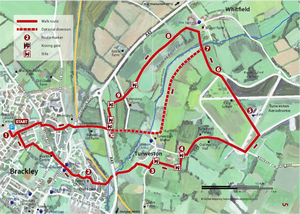
Distance: 6.5 miles (10.5km)
Time to walk: Well this one would normally take around 2.5 hours, but due to circumstances (see below) we finally got back to the car in 4 hours…
Difficulty: Almost completely across fields (& aerodromes)
Parking: Brackley Leisure Centre
Public toilets: Brackley Leisure Centre, the cafe at Turweston Aerodrome & several pubs along the route
Map of the route: Looks easy enough…mmmm….read why later, but we followed the dotted line back
So here we go….we did this walk on Mon 1st July starting under overcast skies which soon burnt away to give a lovely sunny day. Nothing could go wrong. Or could it…
1. Park up in the Leisure Centre car park (free) & now we need to get out of town. So cross over Pavillions Way, up Soudan Avenue & then Bayard Brow (all housing estate). At Martial Daire Boulevard (where does that name come from?) turn left, then right into Daniaud Court & follow the footpath past the Health Centre.
Turn right down Hale Road & you’ll see Church Road (our route) over the road between 2 pubs (it was a bit early…)
2. Cross over at the crossing & head down Church Road – some pretty cottages here on the right. You can now see the church ahead of you…very pretty.
Go into the churchyard, round the left handside & turn right along the lane. At the end bear left and then our path lies down the alley ahead (wouldn’t want to walk down here at night!)
3. The footpath drops down & crosses the river (stream with tyres…) & then through the underpass of the A43. Now we’re heading into the country at last! Keep heading straight until the road splits – we take the right hand turn up past the scout hut.
4. At the t-junction turn left & look out for a footpath sign on the right that passes through a gate & over a stile down the side of some stables
So now’s the start of the fields & now’s the start of the fun…the problem is around this part of Northamptonshire many of the landowners don’t appear to welcome walkers & paths are either not marked, have locked gates, or are overgrown & inaccessible through waste high shrubs & nettles etc….grrr! Any despite being told off twice we carry on.
Follow the field on your left over 2 stiles until you come to this gate
Go though this field, through the next gate & across the next field (sheep) & exit over the stile into a lane.
5. Turn right here & head along until the road bends left – our route is straight ahead
Keep the hedge on your right keep going until you come to a field with an electrified fence round it – it had friendly horses in it. Now….where do we go??? Not a sign in sight. We eventually spotted a stile in the top left of the field so made our way to the left through long grass to a gate that wouldn’t open!! So we climb over then head across and out over the stile
6. Once out of the field go straight until you come to a track & turn left, circling around 2 open storage barns & head straight until you come to the perimeter of Turweston Aerodrome. That day there was plenty of activity as it was the one after the Grand Prix. If you’re pet walking around here there are signs suggesting they should be on a lead…
7. Follow the perimeter road around to the left & then keep straight on heading for what looks like a stack of storage crates.
OK after the crates turn left onto the airfield & continue until you are opposite the road running down to the control tower. Cross over & head towards it passing hangers etc. You’ll see the sign above so go round, order some lunch, grab a seat & watch the planes
8. We got chatting to a local here & he confirmed that previous estate owners had taken up footpath signs… Right retrace your steps & turn right – our trig point is the airsock at the bottom of the airfield
Keep the defunct looking rally school on your left, go straight on & exit the airfield at the gate onto a track. You can now see Whitfield ahead.
9. At the bottom of the track you can see a bridge over the Great Ouse. Now just before this between two paddocks there should be a footpath sign pointing you left & then right up past the sewage works. In the absence of this we headed straight on & into a farm & livery – bad move & another argument!!!!
So retracing our steps we headed up the grass track & turned right past the works onto a white concrete path. The instructions told us to follow this alongside Whitfield ‘point to point’ track which we did through 2 gates for about 1 mile. On reaching & opening the 3rd gate we were suddenly charged by 2 big & very fearsome dogs. We quickly retraced our steps back to the all familiar sewage farm (we were calling it something different by this point…)
10. Decision made then to follow the dotted line path on the map. This basically just goes through different fields so keep the hedge on your right. Have a look out though for the horned cattle in the fields on the right
Eventually we come to the end of a field & there’s a gate on the right & you can see a thatched cottage through it. The gate has a sign facing the other way so after passing through we turn & have a look at what it says…’No right of way…keep out!’ You’re having a laugh…
11. There’s now only one more ticking off to come so let’s head on, exiting the field via a stile into a horse paddock & then out again via another. We’re now back in Turweston &, as there’s no footpath signs, we head along the track to a gate leading out onto a lane. It’s locked with a padlock…
At this point ‘the Lady of the Manor (ha!) appears shrieking “what do you think you’re doing, this is private land”. That’s it…we’ve had enough & give a lecture on responsibilities on private land for public footpaths. She grumpily points us back where we’re come from – we should have gone through waste high nettles down to a small gate. Of course we should…silly us!!
12. Right…we’ve had enough now so turn right down the lane & past the Stratton Arms pub – nice beer garden at the back. Follow the lane up the hill past the owner of the long-horned cattle we saw earlier. You’ve seen them in the field, you can buy them here at Rachel’s Farm Shop & cook them when you get home!
Keep on up the hill. You’ll see a footpath sign on your right which is obviously where the other route comes out. Cross over the A43 & head up the hill, turning left up a small footpath just before the main road.
Cross over & head up Radstone Road taking the first left into Ellesmere Road (we’re back in the housing estate now & both looking like we’ve had enough…). Turn right onto Bridgewater Road, then right again onto Halse Road.
Take the left at the roundabout & go past the school on the right. After the shops turn right & follow the road to where we parked the car.
So….what to say to sum this walk up. Well if the landowners had maintained or signposted the routes it would have been a really good 2.5 hours across some great countryside. However when they don’t it becomes very, very frustrating.
Would I recommend this one to you? Yes, but not on a wet miserable day or you could become very glum!
Go Walk!
Your login details have been used by another user or machine. Login details can only be used once at any one time so you have therefore automatically been logged out. Please contact your sites administrator if you believe this other user or machine has unauthorised access.